Pro tip: do not slack off on your water-drinking once you’re sure the elevation isn’t trying to kill you. After yesterday’s water binge, I felt so much better today. Waking up at 4:30am didn’t hurt quite so much, my legs paid better attention to my brain, and my brain was back on board with this whole adventure.
Drink your water, kids.
We were on the trail by 5am today, which was still dark enough that we needed headlamps. Despite last evening’s little snow shower, there wasn’t a cloud in the sky, and we got to see stars above the mountains for the first time.

But it was cold. Oh boy, was it cold.
When we were packing for this trip, I joked that in a pinch, I could wear everything I’d brought at the same time, and my strategy for today wasn’t far off that mark. Wool tank top, long sleeved wool shirt, fleece pullover, puffer vest, puffer jacket, wool leggings, hiking pants, wool socks, wool gloves, yak hat. Basically all that was missing was my “not fast, not furious” t-shirt.
I wondered if all this might possibly be overkill, given the effort being exerted on an uphill climb. But then I went to have a drink of water (water super-powers!) and discovered the water in the hose from my pack bladder had frozen.
Thankfully, the sun rose shortly after and prevented a repeat of that particular problem.

With the sun up, we had a good view of the challenge in front of us.
You have no idea how great switchbacks are until they don’t exist. Have I said that before? I’ve been thinking it a lot on this trip. Apparently Nepalis always want to take the most direct route to any point, and if going literally straight up the side of a mountain is too steep for human ankles to handle, they’ll make these teeny little zig-zags in grudging accommodation.

But hell if my water-drenched muscles didn’t bistari the bejeezus out of this impossible slope.
“Short break?” Surya kept asking from his position two zags ahead of us. He climbed faster than us, then waited for us to catch up as I plodded step by excruciatingly slow step up the side of that 17,700-foot mountain.
“Nope,” I said to least three offers. “I’m gonna keep going.” I had rediscovered my steady pace, and I was going to milk it for as many vertical feet as I could.
Six hundred feet, as it turns out, in about a third of a mile, in about 45 minutes of constant movement. This might be the single most impressive physical feat I’ve ever performed.
But here’s a lesson I’ve learned in the Himalayas: however far you think you have to go, you actually have to go twice as far as that.
(Remember that. It’s going to come up again.)
I knew the top of this rise was not the top of the pass. I knew we’d have to go higher. I just am completely incapable of estimating how very, very much higher 2,000 feet is, apparently.
It was slow. So slow. We’d tried to generously estimate that the 2.5-mile ascent would take us 3 hours. Over an hour per mile! Surya gently agreed, “yes, three hours. Or maybe four hours.”
Guess who was right?

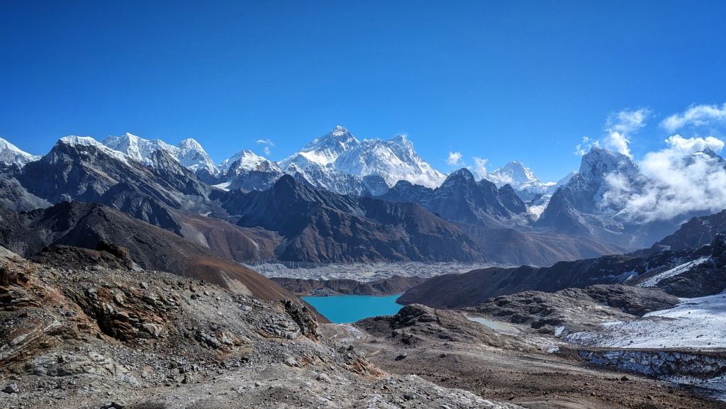
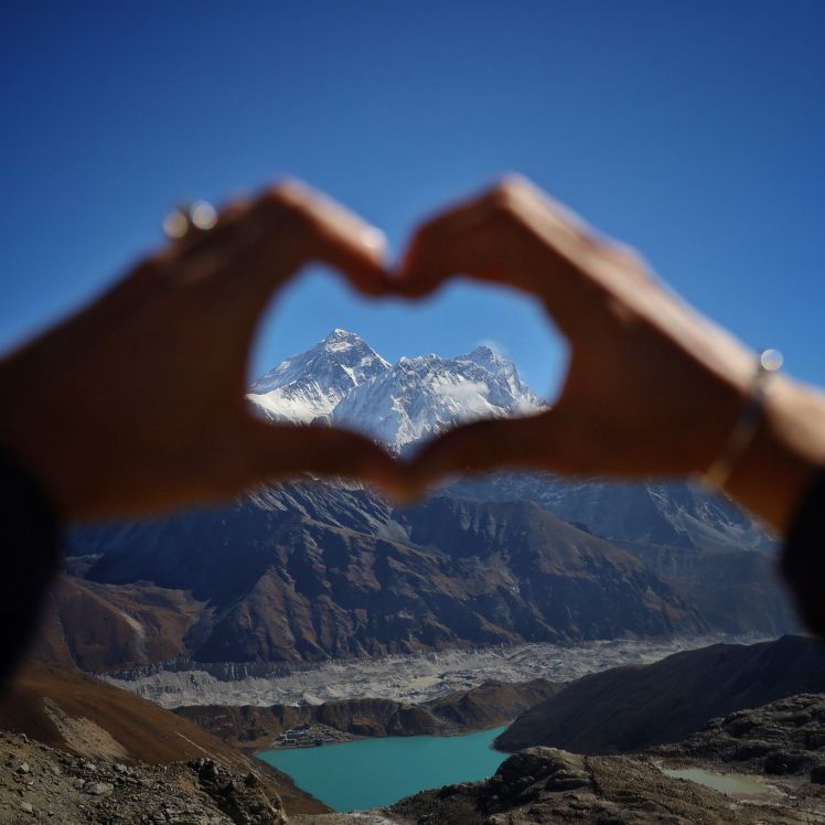
But oh! Was it worth it. I didn’t realize it, but the view from the top of Renjo La pass is what I came here to see.
Everest is on full display from this angle, farther away than the view from Kala Patthar, but no longer hiding behind Nuptse. You can see her whole summit, north shoulder, and part of the north face. More than that, you can see how much bigger she is than everything else around her. Gads, but Everest is immense!
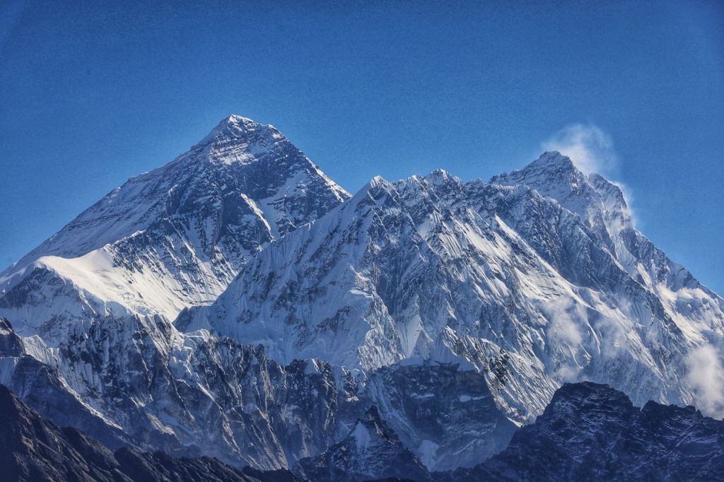
Nuptse and Lhotse were also in fine form, and we had our first good look at Makalu (8,463m/27,830f) in the far distance. Cho Oyu was just out of view to the north, but we’d given her a good ogling from the glacier yesterday.


I could have sat up there for hours soaking them all in. Pictures do them no justice.
But today’s hike down would cover almost six miles, noticeably more than either other pass’s downsides. A few clouds were starting to clutter the view, anyway.
The back side of Renjo La surprised us with a rock-sculpted stairway.
“Before one year ago?” Surya said. “This was a hard way down. Loose rocks everywhere that want to twist your ankle. Now? It’s the easy way.”
I won’t argue with that. This stairway was so beautifully built, I’d wager it had more even treads than the staircases at half the guest houses we stayed at.
At the bottom of the stairs/slope leading down from the pass, we finally found the other people. Thus far, we’d had this hike almost entirely to ourselves, excepting a few porters who’d passed us along the way. At the top, we’d met a group of three who’d gotten there before us, but that had been it. Such an incredible hike to have to ourselves, and view to soak in mostly in peace!
But 250 feet down the back side, the people started appearing. Straggling in twos and threes at first, then in several large clumps of a dozen or more, here came the people who were attacking Renjo La from the other side, having started their morning six miles away in Lunden.

“3am,” Surya said, nodding at one miserable looking group.
“They started at 3am?!” I gasped. It was now past 10am. I remembered the clouds creeping in over the view from the top, half an hour ago. “That wasn’t early enough.”
I thought about how hard our 5am start had been, facing a meager 2,000-foot gain. I imagined starting at 3am with a 3,500-foot gain in front of me. I thought about how, at 10am, it was already too late for these poor souls to get a clear view after all that effort, and I felt desperately, immensely grateful we’d come at it from the other side.
But tackling that 3,500-foot loss was now my lot, and we still had 3,000 of it to go.
Within half an hour, there were no more people hiking uphill anymore, and we had the trail completely to ourselves again. Glorious.
I must be getting better at down, because the village of Lunden arrived well before I started feeling sorry for myself. I am great at this.
(Remember the moral of this story? It’s coming back around for us.)
We ate lunch and discussed our plans. Pushing past Lunden to the next sizable village, Thame, was on the table. Doing this would make today really long, but allow us to cut our final day, scheduled for 12 miles, into a 7-mile day and a 5-mile day, which sounded like a nicer way to finish.
“About three more hours to Thame,” Surya said.
“Yeah, looks like it’s about three or four miles from here,” Dustin said, consulting his map.
We had 8 miles on us already, including 2,000 feet of up and 3,500 feet of down. Could we do another three miles and 2,000 feet down?
I was feeling strong. I was feeling smug.
If I’d asked Dustin for clarification (which I 100% didn’t and why not?!) he’d have said he meant “3-4 miles as the crow flies.” If I’d really paid attention to Surya, I’d have realized he’d never estimate downhill hiking at one hour per mile. If I’d remembered the moral I’d discovered mere hours ago on the other side of the pass…
But no. I wasn’t thinking too deeply about any of this, just about how sleeping in Thame would mean not having to listen to all my doomed neighbors get up at 2am, hawking their loogies and shouting (shouting!) in seven different languages to each other before starting their 3am death march to the pass.
So after lunch, we started for Thame.

The hike was so beautiful, and the trail was surprisingly gentle. (Why would it be gentle, Laura?? What is the ONLY thing that can make a 2,000-foot descent gentle?!) Juniper shrubs started reappearing. We passed three or four villages so picturesque you wanted to weep (or was that your knees after 4,000 feet of descent?).
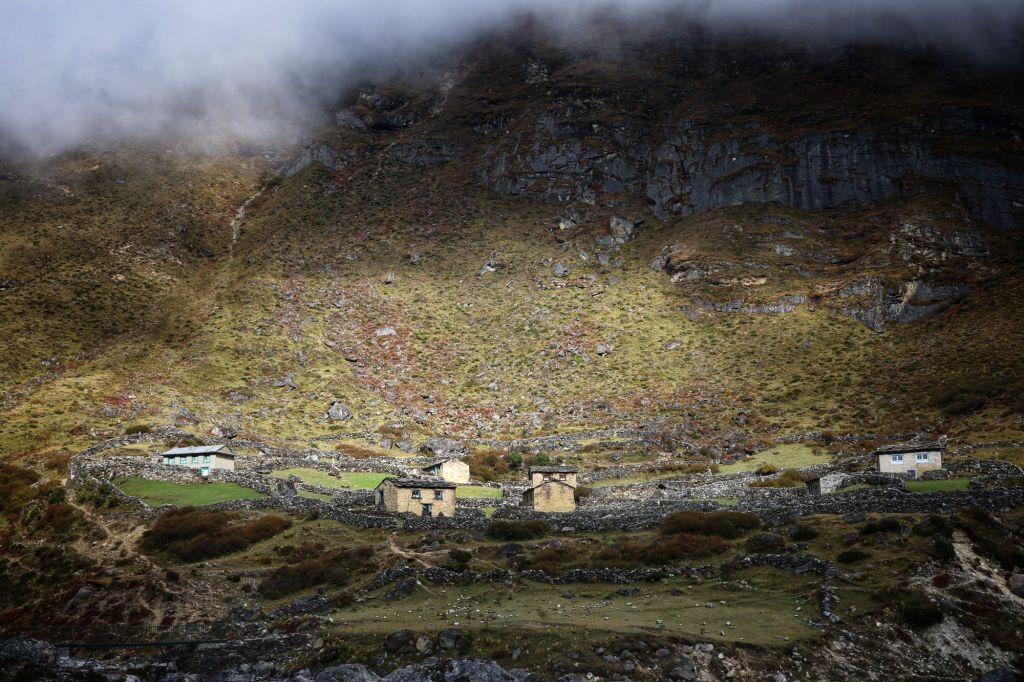
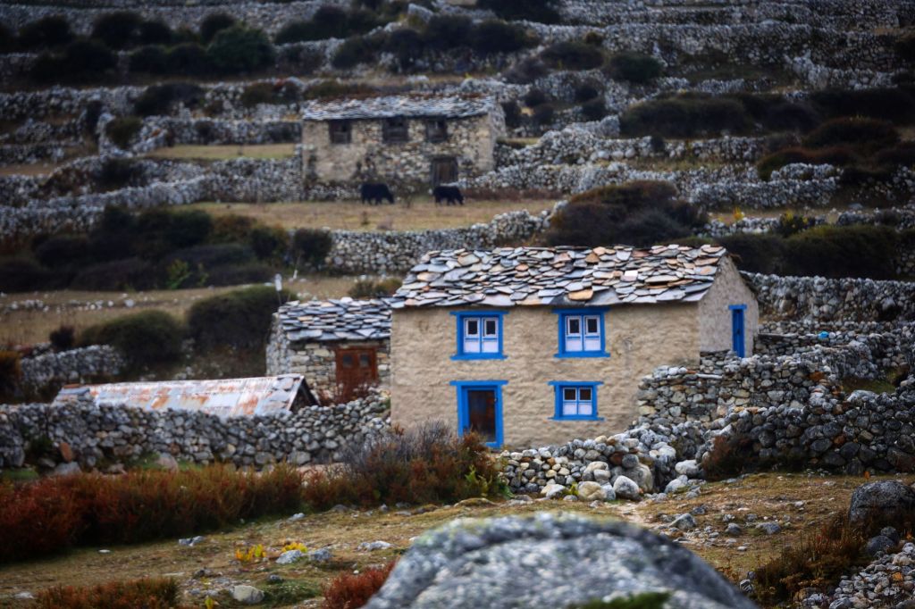

Surya explained that these are real, working villages. The villages up higher? Gorak Shep, Lobuche, Dzongla, Dragnag, Gokyo, and others? They only exist for the tourists. These villages have been here for centuries, for families farming cattle (cows, yaks, buffalo), tending trading routes, and farming the hardy crops that grow in this crazy climate.
“This valley is where most of the Sherpas who work on Everest come from,” Surya said. “In the spring, there are no men living here.” He made a sweeping gesture to show all the Sherpa men marching up the valley into the high mountains.
Three miles came and went and I thought, “guess it’ll be closer to the ‘4’ part of Dustin’s 3-to-4-mile estimate.”
Four miles came and went. I set my jaw and prepared to do some light grumbling when it actually took five.
Five miles approached. Surya had started forging ahead, leaving my ever-slowing carcass behind with Parash to keep an eye on me.
He must be going ahead to make arrangements with the hotel, I thought. We would be unexpected guests in this town, after all.
“Uh, this isn’t Thame,” Dustin said when I voiced this thought aloud.
“What do you mean this isn’t Thame? Oviously this is Thame why would you say such a thing??”
“Nope. This is Hungmo. Thame is three more villages down.”
That was the moment I finally almost sat on a rock and waited for a donkey. I did sit on a rock, anyway. I might have cried a little. There had been a pebble in the toe of my right shoe for the last three miles. A pebble I was supposed to have evicted, along with my shoes themselves, two miles ago. A pebble which would have to stay for however long it took to get to past three more entire villages because if my shoes came off now, there would be zero chance of me putting them back on.
We trudged on, catching sight of Surya every ten minutes or so as he waited for us to catch up. Parash, lugging our big bags strapped to his forehead the whole time, was infinitely patient. “Small break,” or “water break,” he said kindly every time I groaned to a stop at the bottom of yet another rise.
How could we be losing 2,000 feet and still keep having to hike up all these hills?!
And then the signs on buildings we passed finally started saying “Thame.” I almost wept. (Wept some more, I mean.)

Six miles after this three-mile hike started, I lurched up some stairs behind Surya, who was negotiating our accommodations.
“No rooms!” he exclaimed, turning to us with a stunned grin. Surya only ever grins, but his grins contain a multitude.
Two days ago, the clouds had finally lifted over the airport in Lukla, allowing 1,700 trekkers to start hikes that – in two days – would have brought them exactly this far. All the guest houses on the bottom half of the Everest-range loop were swamped, even here along one of the less-popular trails.
I trailed after him as he followed the owner of the full guest house down a little street toward, presumably, alternate lodgings. I pulled the edge of my buff all the way up to meet the edge of my sunglasses to try to hide that I was crying. Again. Still?
Good thing I’ve been hydrating.
14 miles. 2,500 feet up. 155,500 feet down. I still had a rock in my shoe, and I was done.
Thankfully, this second guest house still had rooms. The removal of my shoes, my first legitimately hot shower in more than two weeks, and the promise that we could sleep in the next morning did much to repair my mood, though my equilibrium has remained a bit out of balance ever since.
I had forgotten, of course, the very lesson I had formulated that morning after conquering the first major rise on the trail: however far you think you have to go, you actually have to go twice as far as that. It had been literally true at least three times today. Setting my expectations appropriately and then reacting appropriately when they aren’t met is something I always struggle with. Thinking back, I see that in this case my mental game gave out even before my body needed to quit. Today was hard, yes, but holy heck I did it and I don’t even think I’ll be paying any physical price for it tomorrow.
But that shower? That shower was really good. I may be feeling tougher than I’ve ever felt before, but that shower reminded me how much I love the soft things. Today I got back trees and running water. I’m ready to keep adding to that list.
- Starting location: Gokyo, 4,800m (15,744 feet)
- Max elevation: Renjo La, 5,360m (17,764 feet)
- Ending location: Thame, 3,800m (12,464 feet)
- Cumulative elevation gained: 845m (2,773 feet)
- Elevation lost: (5,300 feet – a personal elevation-change record unlikely to ever be beat)
- Distance: 14.1 miles in 8:51’01” active time, 11:13’42” total
- Average Pace: 38’47” per mile
- Slowest mile: 1:31’58”

Are you sure you have the right order for this caption: [Everest on the right, Nuptse up front, and Lhotse on the left. 🤍]?
LikeLike
Here’s a fun fact about me: I am 42 years old and cannot tell the difference between left and right. It has caused me a lot of problems in my life. This one is minor, but you are totally correct, and THANK YOU. All fixed. 🤦♀️
LikeLike
Heh. I have a very good friend who’ll be 50 at the end of the month, and she can’t, either. 🙂 It’s all good!
I am totally enjoying your accounts of your travels–all of them! You continue to be one of the most gifted writers I “know.”
LikeLiked by 1 person
Amazing journey Laura & Dustin!!
LikeLike